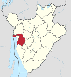
Bujumbura Rural Province
Bujumbura Rural Province | |
|---|---|
 | |
| Country | |
| Capital | Isale |
| Area | |
| • Total | 1,319.12 km2 (509.32 sq mi) |
| Population (2020) | |
| • Total | 730,000 |
| • Density | 550/km2 (1,400/sq mi) |
| [1] | |
| Time zone | UTC+2 (CAT) |
Bujumbura Rural Province is one of the eighteen provinces of Burundi. Former President Cyprien Ntaryamira was born here. It surrounds the former national capital Bujumbura and its provincial capital is Isale.[2]
Location[edit]
Bujumbura Rural Province is in the east of Burundi, to the east and north of Lake Tanganyika. In the northeast it borders the Democratic Republic of the Congo. To the north it borders [[Bubanza Province, to east it borders Muramvya Province and Mwaro Province, and to the south it borders Bururi Province. It encloses Bujumbura Mairie Province around the northwest corner of Lake Tanganyika. In the west it is in the Imbo natural region. The center is in the Mumirwa natural region and the east in the Mugamba natural region.[3]
Communes[edit]
Bujumbura Rural Province administers nine communes:[2]
- Commune of Isale
- Commune of Kabezi
- Commune of Kanyosha
- Commune of Mubimbi
- Commune of Mugongomanga
- Commune of Mukike
- Commune of Mutambu
- Commune of Mutimbuzi
- Commune of Nyabiraba
References[edit]
- ^ Law, Gwillim. "Provinces of Burundi". Statoids. Retrieved 13 July 2015.
- ^ a b Nkurunziza, Pierre (26 March 2015). "LOI No 1/10 DU 26 MARS 2015 PORTANT CREATION DE LA PROVINCE DU RUMONGE ET DELIMITATION DES PROVINCES DE BUJUMBURA, BURURI ET RUMONGE" (PDF). Presidential Cabinet, Republic of Burundi. Retrieved 14 July 2015.
- ^ Atlas des quatre sites Ramsar.
Sources[edit]
- Atlas des quatre sites Ramsar: Localisation et Resources (PDF) (in French), Ministry of Water, Environment and Urbanism, October 2014, retrieved 2024-06-22
3°22′44″S 29°25′36″E / 3.37889°S 29.42667°E
